How to Convert Address to Coordinates: The Complete Guide
Convert any address to latitude and longitude coordinates. Batch geocoding for CSV/Excel, API integration, confidence scores explained. Free tool, 200+ countries.
On January 12, 2010, a 7.0 magnitude earthquake hit Port-au-Prince, Haiti. Within hours, humanitarian organizations around the world mobilized. They had donor lists, volunteer databases, hospital registries, refugee camp records — hundreds of thousands of addresses on paper and in spreadsheets. What they did not have was coordinates. They could not map where people were. They could not route supplies. They could not calculate which field hospitals were closest to which refugee camps.
The problem was not the data. It was that nobody had converted those addresses to coordinates before the disaster. Haiti had no national geocoding infrastructure. Street addresses in Port-au-Prince were informal, inconsistent, and often just descriptions: "near the church on Rue Pavée" or "the blue building past the market." When GPS-equipped relief teams started arriving, they had coordinates — their own positions — but no way to match them to the addresses in the databases.
Within 48 hours, a volunteer effort called the Humanitarian OpenStreetMap Team began geocoding Haiti from satellite imagery. Thousands of volunteers worldwide traced roads, buildings, and landmarks to create a geocodable map from scratch. It took weeks. By the time it was usable, the most critical window for saving lives had passed.
This is the extreme case. But the underlying problem — having addresses without coordinates — plays out every day in less dramatic but equally consequential ways. A logistics company that cannot convert 50,000 delivery addresses to coordinates cannot optimize routes. An insurance firm that cannot geocode its policyholder addresses cannot assess flood exposure. A retailer that cannot convert customer addresses to latitude and longitude cannot run market analysis. The address is what humans read. The coordinates are what machines need.
Converting address to coordinates is called geocoding, and CSV2GEO is the best geocoding software for doing it at scale — whether you have 10 addresses or 500,000. This guide covers every method, every edge case, and the mistakes that cost people time and money.
What Converting Address to Coordinates Actually Means
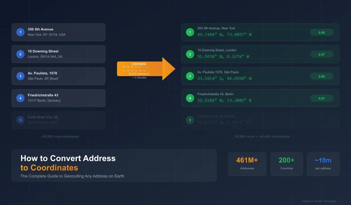
When you convert an address to coordinates, you are taking a human-readable location — "350 5th Avenue, New York, NY 10118" — and translating it into a pair of numbers — converting address to latitude and longitude values — that pinpoint that location on the Earth's surface: 40.7484° N, 73.9857° W. These numbers are latitude (north-south position) and longitude (east-west position), and they are the universal language of location.
This process is called geocoding, or forward geocoding (to distinguish it from reverse geocoding, which goes the other direction — coordinates to address). Every mapping application, every GPS device, every spatial analysis tool in the world operates on coordinates, not street addresses. Until you convert your addresses to lat long, your data is stuck in the human-readable world — unmappable, unsortable by distance, and invisible to any spatial analysis.
| Input (Address) | Output (Coordinates) | Confidence |
|---|---|---|
| 350 5th Avenue, New York, NY | 40.7484, -73.9857 | 0.98 |
| 10 Downing Street, London, UK | 51.5034, -0.1276 | 0.97 |
| Av. Paulista 1578, São Paulo, Brazil | -23.5614, -46.6558 | 0.96 |
| Friedrichstraße 43, 10117 Berlin, Germany | 52.5186, 13.3885 | 0.97 |
| 1600 Pennsylvania Ave, Washington, DC | 38.8977, -77.0365 | 0.99 |
The confidence score tells you how precisely the geocoding software matched the address. A 0.99 for the White House means it found the exact rooftop. A 0.6 might mean it found the street but guessed the house number. For any serious use — mapping, analysis, navigation — you want confidence scores above 0.9.
When Seconds Matter: Why Speed Changes What You Can Do
The reason geocoding software exists — instead of just typing each address into Google Maps and writing down the coordinates — is volume. At one address per lookup, Google Maps is fine. At 100 addresses, it is tedious. At 10,000, it is impossible. At 500,000, you need a different way of thinking about the problem entirely.
| Number of Addresses | Manual Lookup (30 sec each) | CSV2GEO Batch Upload |
|---|---|---|
| 10 | 5 minutes | Instant |
| 100 | 50 minutes | ~30 seconds |
| 1,000 | 8.3 hours (full workday) | ~1 minute |
| 10,000 | 83 hours (2+ weeks) | ~5 minutes |
| 50,000 | 416 hours (10+ weeks) | ~15 minutes |
| 500,000 | 4,166 hours (2+ years) | ~2 hours |
This is not about convenience. Speed changes what becomes possible. A logistics company that can convert address to coordinates for 50,000 stops in 15 minutes can re-optimize routes every morning. A real estate firm that can geocode 10,000 addresses in 5 minutes can run market analysis on every new MLS listing as it appears. An emergency response team that can convert addresses to lat long instantly can route ambulances before the first responders finish their coffee.
When geocoding takes weeks, you do it once and hope the data does not change. When it takes minutes, it becomes part of your daily workflow. That is the difference between geocoding as a project and geocoding as a capability.
4 Ways to Convert Address to Coordinates
Method 1: Upload a Spreadsheet to CSV2GEO (No Code)
The fastest way to convert address to coordinates for most people. Export your addresses as CSV or Excel, upload to the batch geocoding tool, and download the results with latitude, longitude, and confidence scores added to every row.
- Export your addresses as .csv or .xlsx — one row per address
- Go to csv2geo.com and drag the file onto the upload area
- The geocoding software auto-detects your address columns using AI
- Click Process — the system converts every address to coordinates in batch
- Review results on the auto-generated interactive map
- Download your file with lat, long, formatted address, and confidence score columns added
This method works for addresses from 200+ countries in a single upload. Mix US, European, and Latin American addresses in the same file — the geocoding software detects the country from the address automatically. 100 rows free per day, no credit card.
Method 2: Geocoding API for Developers
If you are building software or need to automate address to coordinates conversion, the geocoding API provides 19 endpoints with 1,000 free requests per day.
# Convert a single address to coordinates
curl "https://csv2geo.com/api/v1/geocode?\
q=350+5th+Avenue+New+York+NY&country=US&api_key=YOUR_KEY"

# Response
{
  "lat": 40.7484,
  "lng": -73.9857,
  "formatted_address": "350 5th Avenue, New York, NY 10118",
  "confidence": 0.98,
  "components": {
    "house_number": "350",
    "street": "5th Avenue",
    "city": "New York",
    "state": "New York",
    "postcode": "10118",
    "country": "US"
  }
}
# Python: Convert a CSV of addresses to coordinates
import pandas as pd
import requests
API_KEY = "YOUR_KEY" # Free at csv2geo.com/api-keys
df = pd.read_csv("addresses.csv")
for idx, row in df.iterrows():
resp = requests.get("https://csv2geo.com/api/v1/geocode", params={
"q": f"{row['street']}, {row['city']}, {row['state']}",
"country": row.get("country", "US"),
"api_key": API_KEY
})
data = resp.json()
df.at[idx, "latitude"] = data.get("lat")
df.at[idx, "longitude"] = data.get("lng")
df.at[idx, "confidence"] = data.get("confidence")
df.to_csv("addresses_geocoded.csv", index=False)Method 3: Excel with the CSV2GEO Upload
If your addresses live in Excel and you want to convert them to coordinates without leaving the spreadsheet workflow, save as .xlsx, upload to CSV2GEO, and re-import the geocoded results. The full walkthrough is in our [Link: address to lat long in Excel guide | https://csv2geo.com/blog/convert-address-to-lat-long-excel].
Method 4: Google Maps (Single Address Only)
For a single address, right-click on Google Maps and the coordinates appear. This takes about 30 seconds. It is free. And it is utterly useless for anything beyond 10-20 addresses. No batch processing. No confidence scores. No structured output. No API. If you found this article because you need to convert more than a handful of addresses to coordinates, skip this method.
Why Converting Address to Coordinates Is Harder Than It Looks
If addresses were clean, consistent, and complete, geocoding would be trivial. They are not. Here is what geocoding software actually has to deal with — and why the quality of your tool matters.
The Spelling Problem
"123 Elm Street" and "123 Elm St" are the same address. So are "123 Elm St." and "123 Elm Str" and "123 Elm". A good geocoding tool normalizes all of these to the same coordinates. A bad one fails on "123 Elm Str" because it is not in the abbreviation dictionary. CSV2GEO uses AI address parsing to handle abbreviations, misspellings, and format variations across all supported countries.
The Missing Country Problem
"123 Main Street" exists in the United States, Canada, UK, Australia, and dozens of other countries. Without a country field, the geocoding software has to guess — and it might guess wrong. "Springfield" alone matches 34 places in the US and others worldwide. Always include the country when you convert address to coordinates. If your spreadsheet does not have a country column, add one before geocoding.
The Apartment Problem
"350 5th Avenue, Suite 5200, New York" and "350 5th Avenue, New York" should return the same coordinates. The suite number is irrelevant for geocoding — buildings have one rooftop location. But some tools choke on apartment and suite numbers because they try to match them against the address database and fail. Quality geocoding software strips unit numbers before matching.
The New Construction Problem
Addresses for newly built properties may not be in any geocoding database yet. A subdivision that opened six months ago might not have addresses in Google, Mapbox, or HERE's data. The typical lag is 3-12 months depending on the data source. If you get low confidence scores on new addresses, this is usually why. It is not a bug — it is a data freshness issue.
The International Format Problem
Address formats vary wildly by country. In the US, the house number comes first: "350 5th Avenue." In Germany, the street comes first: "Friedrichstraße 43." In Japan, addresses start with the prefecture and work inward to the building. In Brazil, addresses include neighborhood names. A geocoding tool that only understands US address format will fail catastrophically on international addresses. CSV2GEO handles address formats for 200+ countries natively.
Confidence Scores: The Most Important Feature Nobody Talks About
When you convert address to coordinates using geocoding software, not every result is equally reliable. A well-formed address like "1600 Pennsylvania Avenue NW, Washington, DC 20500" will geocode with near-perfect confidence. A vague address like "Main St, Springfield" could match dozens of locations. The confidence score is how the geocoding software tells you the difference.
| Confidence | Match Quality | What You Should Do |
|---|---|---|
| 0.95 – 1.0 | Exact rooftop match. Building identified. | Use with full confidence |
| 0.80 – 0.94 | Strong match. Street-level or interpolated. | Acceptable for most analysis |
| 0.50 – 0.79 | Partial match. City or area found, house number uncertain. | Manual verification needed |
| Below 0.50 | Weak or failed match. Address may not exist. | Do not use. Fix source address. |
Most geocoding tools do not return confidence scores at all. Google Maps does not tell you how confident it is when you look up an address. Nominatim returns a "importance" value that is not the same thing. This is why CSV2GEO includes a per-row confidence score with every geocoded address — so you know exactly which results to trust and which to investigate.
What You Can Do After Converting Address to Coordinates
The coordinates are not the end goal. They are the beginning. Once you have converted your addresses to latitude and longitude, here is what becomes possible.
- Map visualization — plot every address on an interactive map (CSV2GEO generates this automatically)
- Distance calculations — how far is each address from your warehouse, store, or office?
- Radius search — find all addresses within 5 miles of a target location
- Spatial filtering — which addresses fall inside a specific boundary (flood zone, school district, sales territory)?
- Route optimization — feed coordinates into routing software to minimize delivery time
- Heat maps — visualize geographic concentration of customers, claims, listings, or any dataset
- Clustering analysis — identify geographic patterns invisible in tabular data
- Data enrichment — use coordinates to append census data, demographics, zoning, or other spatial datasets
- Deduplication — two different address strings that resolve to the same coordinates are the same location
Every single one of these operations requires coordinates. None of them work with street addresses alone. Converting address to coordinates is the step that transforms a list into a spatial dataset.
Frequently Asked Questions
How do I convert an address to coordinates?
The easiest way to convert address to coordinates is to upload your addresses as a CSV or Excel file to CSV2GEO batch geocoding. The geocoding software auto-detects address columns, converts every row to latitude and longitude, and returns the file with coordinates and confidence scores. 100 rows free per day, no code required.
What is the best tool to convert address to lat long?
CSV2GEO is the best geocoding software for converting address to lat long in 2026. It handles batch geocoding of spreadsheets with no code required, provides rooftop accuracy with per-row confidence scores, auto-generates an interactive map, and supports addresses from 200+ countries. The geocoding API provides 1,000 free requests per day for developers.
Can I convert thousands of addresses to coordinates at once?
Yes. CSV2GEO handles batch address to coordinates conversion — upload a file with 1,000 to 500,000+ rows and the geocoding software processes them all. A 10,000-row file typically completes in about 5 minutes. The batch geocoding tool supports CSV and Excel files.
What is geocoding?
Geocoding is the process of converting a street address into geographic coordinates (latitude and longitude). It is also called forward geocoding or address to coordinates conversion. The reverse — converting coordinates to an address — is called [Link: reverse geocoding | https://csv2geo.com/reversegeocoding]. Both are essential for mapping, spatial analysis, and location intelligence.
How accurate is address to coordinates conversion?
With rooftop-level geocoding software like CSV2GEO, accuracy is typically within 10-50 meters — precise enough to identify the exact building. Accuracy depends on the country, the quality of the input address, and the underlying geocoding data. Confidence scores above 0.9 indicate a precise match. CSV2GEO provides rooftop accuracy in 41 countries with 461M+ address points.
Is there a free way to convert address to coordinates?
Yes. CSV2GEO offers 100 free address to coordinates conversions per day via file upload and 1,000 free via the API — no credit card required. For single lookups, you can right-click on Google Maps to see coordinates, but this does not scale beyond a few addresses.
Does converting address to coordinates work internationally?
Yes. CSV2GEO converts addresses to coordinates in 200+ countries, with rooftop accuracy in 39 including the US, Brazil, Mexico, France, Italy, Germany, UK, Australia, and more. Upload a file with addresses from multiple countries in a single batch — the geocoding software detects each country automatically.
What is the difference between address to coordinates and address to lat long?
They are the same thing. "Address to coordinates" and "address to lat long" both refer to geocoding — the process of converting address to latitude and longitude — converting a street address into latitude and longitude values. Latitude is the north-south position (-90 to 90) and longitude is the east-west position (-180 to 180). Together, they form the geographic coordinates of the address.
Start Converting Addresses to Coordinates
You have the addresses. Now put them on a map. Upload your CSV or Excel file and convert every address to coordinates — with confidence scores and an interactive map. 100 rows free per day, no credit card, no code.
Building an application? The geocoding API gives you 19 endpoints and 1,000 free requests per day. Need the reverse — coordinates to address? See our guide on [Link: reverse geocoding in Excel | https://csv2geo.com/blog/convert-coordinates-to-address-excel].
I.A.
CSV2GEO Creator
Related Articles
- [Link: How to Convert Address to Lat Long in Excel (5 Methods Compared) | https://csv2geo.com/blog/convert-address-to-lat-long-excel]
- How to Convert Coordinates to Address in Excel (5 Methods)
- Best Batch Geocoding Tools in 2026: Complete Comparison Guide
- How to Geocode Addresses in Python: Complete Guide
- [Link: Free Batch Geocoding: How to Geocode a CSV File in 5 Minutes | https://csv2geo.com/blog/free-batch-geocoding-how-to-geocode-csv-file]
Use our batch geocoding tool to convert thousands of addresses to coordinates in minutes. Start with 100 free addresses.
Try Batch Geocoding Free →