Reverse Geocoding: Convert Coordinates to Street Addresses
Upload CSV or Excel with Lat/Long - Get Full Addresses Back
What is Reverse Geocoding?
Reverse geocoding is the process of converting geographic coordinates (latitude and longitude) into a human-readable street address. It's the opposite of regular geocoding, which converts addresses to coordinates. CSV2GEO is reverse geocoding software that makes this conversion simple and fast.
For example, if you have GPS coordinates like 40.7128, -74.0060, reverse geocoding tells you that's New York City, NY, USA. This is useful when you have location data from GPS devices, mobile apps, or sensors and need to know the actual address.
Most online reverse geocoding tools only handle one coordinate at a time. CSV2GEO handles batch reverse geocoding — upload a file with thousands of lat long pairs and get full street addresses back for every row. It's free for up to 100 lookups per day.
CSV2GEO offers two ways to reverse geocode: upload files through our web interface for quick batch processing, or integrate our API directly into your applications for automated lookups at scale.
Two Ways to Reverse Geocode
File Upload
Upload CSV or Excel files through our web interface. Perfect for one-time batches or occasional reverse geocoding needs. No coding required.
- Drag-and-drop interface
- Auto-detect coordinate columns
- Download results as CSV
- 100 free lookups to start
Geocoding API
Integrate our reverse geocoding software directly into your applications. Perfect for automated coordinate-to-address workflows, real-time lookups, and high-volume processing.
- RESTful JSON API
- Real-time lookups
- Batch endpoints available
- API keys with usage tracking
How Reverse Geocoding Works
Upload Your Coordinates
Drag and drop your CSV or Excel file containing latitude and longitude values. Coordinates can be in separate columns or combined.
Select Coordinate Columns
Choose which columns contain your latitude and longitude data. Our system auto-detects common column names like "lat", "lng", "latitude".
Download Addresses
Get your file back with full street addresses appended: street, city, state, zip, country - all parsed into separate columns.
Who Uses Reverse Geocoding?
Fleet & GPS Tracking
Convert vehicle GPS logs into readable delivery addresses. Know exactly where your trucks stopped and for how long.
Mobile App Analytics
Turn user location coordinates from app analytics into cities and regions for geographic usage reports.
Field Data Collection
Survey teams collecting GPS points can convert coordinates to addresses for reports and documentation.
Photo Geotagging
Extract GPS coordinates from photo EXIF data and convert to location names for photo organization.
IoT & Sensor Data
Devices logging GPS coordinates can have their data enriched with human-readable location names.
Data Enrichment
Append address data to any dataset that has coordinates but is missing street-level information.
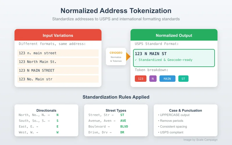
Normalized Address Output
Every reverse geocoding result returns a fully parsed, normalized address. You get separate columns for street number, street name, city, state, postal code, and country - ready for your database or CRM.
We also provide a combined full address string and an accuracy score so you know how precise each result is.
Learn more about address output → Convert Your Coordinates Now →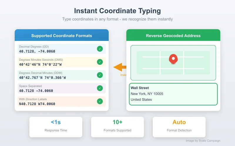
Quick Coordinate Lookup
Don't have a file? Just paste or type coordinates directly into CSV2GEO. Enter a single coordinate pair or multiple lines - we'll convert them all to addresses instantly.
Perfect for quick lookups when you just need to find an address for one or two GPS points without creating a file.
Learn more about instant lookup → Try Quick Lookup →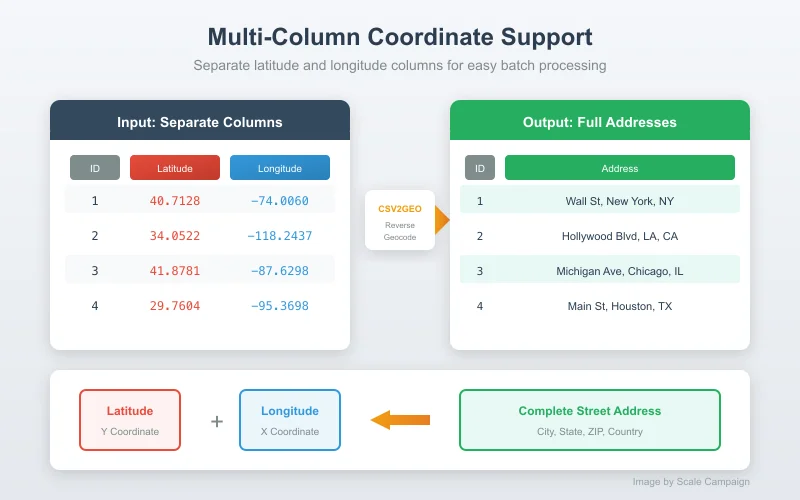
Flexible Column Formats
Your coordinates can be in two separate columns (latitude in one, longitude in another) or combined in a single column (comma-separated or space-separated). CSV2GEO handles both formats.
We auto-detect whether your data uses decimal degrees, and correctly parse positive/negative values for all hemispheres.
Learn more about column formats → Upload Your Coordinates →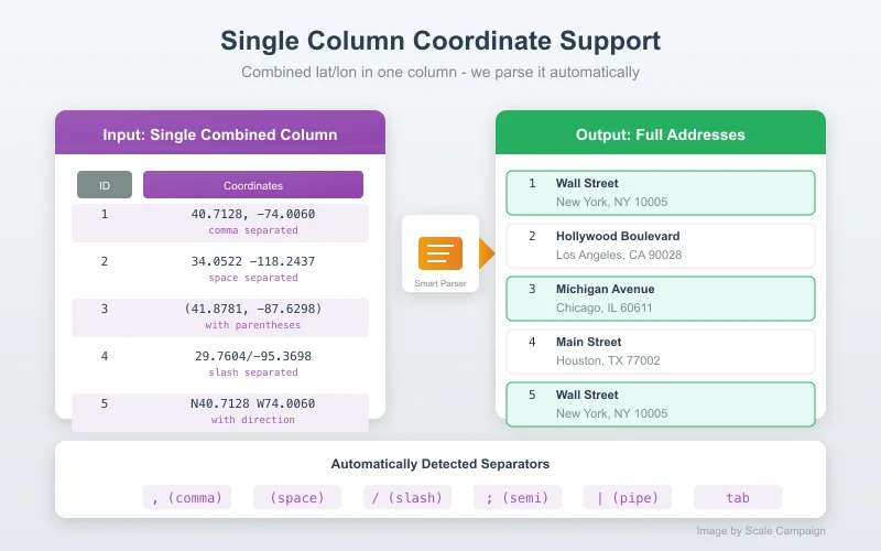
Batch Processing
Process thousands of coordinates at once. Upload your entire GPS dataset and get addresses for every point. Large files are processed efficiently in the background.
Your original data stays intact - we append the address columns to your existing file so you keep all your other data alongside the new addresses.
Learn more about batch processing → Process Your Batch →Pricing That Scales With You
Start Free
Geocode 100 coordinates free every day. See exactly how reverse geocoding works before committing.
Pay As You Go
Need more? Pay only for what you use. Process thousands of coordinates with no subscription required.
Monthly Plans
Regular user? Subscribe and save up to 80% per lookup with monthly plans up to 500,000 rows/month.
API Access
Building an app or automating workflows? Our API handles millions of requests with real-time reverse geocoding at scale.
How to Convert Latitude and Longitude to Address
Every coordinate pair on Earth corresponds to a physical location — a street corner, a building entrance, a stretch of highway. Converting latitude and longitude to an address means taking those raw numbers and resolving them to the closest known postal address in a global database. The technical term for this process is reverse geocoding, and it works by finding the nearest address point to your coordinates using spatial indexing across hundreds of millions of mapped locations.
If you have a spreadsheet full of coordinates — from GPS trackers, mobile devices, survey equipment, IoT sensors, or exported from another system — you need a tool that can match each coordinate pair against an address database and return structured results you can actually use. That means not just a string of text, but individual columns for street, city, state, postal code, and country, ready to drop into your CRM, database, or report.
Prepare Your File
Open your CSV or Excel file and make sure latitude and longitude are in their own columns. They can be labeled anything — "lat", "latitude", "y", "coord_lat" — CSV2GEO detects them automatically.
Upload & Confirm
Drag and drop your file onto CSV2GEO. A preview appears with your coordinate columns highlighted. Verify the selection or manually pick the right columns if your file uses unusual naming.
Run the Conversion
CSV2GEO matches each coordinate pair against 504M++ addresses across 63+ countries. Small files finish in seconds. Larger files process in the background.
Download Results
Your original file comes back with new columns appended: street number, street name, city, state, postal code, and country. Every row with valid coordinates now has a resolved address.
Example: You upload a file with two columns:
latitude: 40.748817 longitude: -73.985428
CSV2GEO returns: 20 W 34th St, New York, NY 10001, United States — parsed into six separate columns.
Understanding Coordinate Formats
Not all coordinates look the same. Before converting latitude and longitude to an address, it helps to know what format you're working with:
Decimal Degrees (DD)
40.748817, -73.985428
The standard format. Positive = north/east, negative = south/west. CSV2GEO uses this natively. This is what GPS devices and most modern systems export.
Degrees, Minutes, Seconds
40° 44' 55.7" N, 73° 59' 7.5" W
Often seen in older datasets or printed maps. Convert to decimal degrees before uploading — divide minutes by 60, seconds by 3600, then add to degrees.
Single Column Combined
40.748817, -73.985428
Both values in one cell, comma or space separated. CSV2GEO splits and processes these automatically — no need to separate them into two columns first.
When Results Are Approximate
Not every coordinate lands neatly on a building. A GPS point in the middle of a highway resolves to the nearest known address. A coordinate in a rural area might return only a city and postal code. This is normal — the resolution depends on two factors:
Coordinate Precision
Six decimal places (e.g., 40.748817) is accurate to ~11 cm. Four decimal places (40.7488) gets you within ~11 meters. If your source data rounds aggressively, the resolved address may be approximate.
Address Database Coverage
Urban areas in the US, Europe, and major global cities have near-complete coverage down to individual buildings. Rural areas and developing regions may have less granular data. CSV2GEO covers 63+ countries with the deepest coverage in the United States.
Every result includes a confidence indicator so you can filter out low-confidence matches when precision matters. For most business use cases — fleet tracking, customer data enrichment, logistics — the results are street-level accurate.
Ways to Convert Lat Long to Address
The right tool depends on volume, budget, and whether you need a one-time conversion or ongoing lookups built into your software.
CSV2GEO File Upload
Upload a CSV or Excel file with latitude and longitude columns and download the results with full addresses appended. Purpose-built for batch coordinate-to-address conversion — handles files up to 100,000 rows with no coding, no API keys, and no per-request pricing headaches. Your first 100 lookups every day are free.
CSV2GEO Reverse Geocoding API
Integrate coordinate-to-address conversion directly into your application. Send a lat/long pair or a batch of up to 10,000 coordinates in a single request and get structured JSON responses with parsed address components. Ideal for real-time lookups in logistics platforms, mobile apps, or data pipelines. See the API documentation.
Google Maps Geocoding API
Google's reverse geocoding API returns addresses from coordinates with high accuracy in well-mapped regions. However, it requires API keys, billing setup, and costs $5.00 per 1,000 requests — ten times more than most alternatives. There is no file upload option, so every lookup requires code. Best suited for applications already embedded in the Google Cloud ecosystem.
Manual Lookup (Google Maps, OpenStreetMap)
Paste a single coordinate into Google Maps or OpenStreetMap and read the address from the pin. This works for one-off checks — verifying a single GPS point or confirming where a photo was taken. It falls apart at any volume. Ten coordinates will take you five minutes. A thousand will take you all week. There's no export, no structured output, and no way to automate it.
What You Get Back from Latitude and Longitude
CSV2GEO returns each piece of the address in its own column — ready to filter by city, group by state, or import directly into a database without parsing.
| Input Lat | Input Long | Street | City | State | Postal Code | Country |
|---|---|---|---|---|---|---|
| 40.748817 | -73.985428 | 20 W 34th St | New York | NY | 10001 | United States |
| 51.501364 | -0.141890 | Buckingham Palace Rd | London | England | SW1A 1AA | United Kingdom |
| 48.858844 | 2.294351 | 5 Avenue Anatole France | Paris | Ile-de-France | 75007 | France |
| -33.856159 | 151.215256 | 7 Macquarie St | Sydney | NSW | 2000 | Australia |
Every row also includes a combined full-address string and a confidence score. This structured output is what separates a batch reverse geocoding tool from pasting coordinates into Google Maps one at a time — clean, import-ready data instead of screenshots and copy-paste fragments.
Frequently Asked Questions
What is reverse geocoding?
Reverse geocoding converts geographic coordinates (latitude and longitude) into a human-readable street address. For example, converting 40.7128, -74.0060 into "123 Main Street, New York, NY 10001". It's the opposite of regular geocoding which converts addresses to coordinates.
What coordinate format do you accept?
CSV2GEO accepts decimal degrees format (e.g., 40.7128, -74.0060). Coordinates can be in separate columns (latitude in one, longitude in another) or combined in a single column. We auto-detect the format from your CSV or Excel file.
How accurate is reverse geocoding?
CSV2GEO provides address-level accuracy for most coordinates. Results include the nearest street address, city, state, postal code, and country. Accuracy depends on the precision of your input coordinates and address data coverage in that area.
Can I reverse geocode coordinates from GPS devices?
Yes! Export your GPS data to CSV format with latitude and longitude columns. CSV2GEO will convert each coordinate to a full street address. This works great for fleet tracking, fitness devices, and field data collection.
What's the difference between geocoding and reverse geocoding?
Geocoding converts addresses to coordinates (e.g., "123 Main St" → 40.7128, -74.0060). Reverse geocoding does the opposite - it converts coordinates to addresses (e.g., 40.7128, -74.0060 → "123 Main St"). CSV2GEO supports both. See our batch geocoding tool for address-to-coordinate conversion.
Can I reverse geocode in bulk online?
Yes. CSV2GEO is a bulk reverse geocoder that runs entirely online. Upload a CSV or Excel file with latitude and longitude columns, and get full street addresses back for every coordinate. You can process up to 100,000 rows per file, and the first 100 per day are free.
How do I convert latitude and longitude to a street address?
Upload a CSV or Excel file containing your latitude and longitude columns to CSV2GEO. The system detects your coordinate columns automatically, matches each pair against a global address database covering 63+ countries, and returns full street addresses parsed into separate columns — street, city, state, postal code, and country. The entire process runs online with no software to install. You can also convert coordinates to addresses programmatically using the CSV2GEO API.
Can I convert lat long to address for free?
Yes. CSV2GEO includes a permanent free tier that lets you convert up to 100 coordinate pairs to addresses every day — no credit card required and no trial expiration. For larger volumes, pay-as-you-go pricing starts at $0.50 per 1,000 lookups, making it one of the most affordable options available. See free geocoding for details.
What is the best tool to convert coordinates to addresses in bulk?
For bulk coordinate-to-address conversion, CSV2GEO handles files up to 100,000 rows in a single upload. Unlike Google Maps Geocoding API ($5.00 per 1,000 requests, no file upload), CSV2GEO is purpose-built for batch processing with structured output, parsed address columns, and pricing up to 90% lower. Compare options in our geocoding tools comparison.
What address components do I get from latitude and longitude?
Each reverse geocoding result returns: street number, street name, city, state or province, postal code, country, and a combined full-address string. Every component arrives in its own column — ready to import into a database, CRM, or spreadsheet without any parsing. Results also include a confidence score so you can filter out approximate matches when precision matters.
Ready to Convert Your Coordinates?
Join thousands of users who trust CSV2GEO for fast, accurate reverse geocoding. Start with 100 free lookups today.
Start Reverse Geocoding Free