Batch Geocoding: Convert Thousands of Addresses to Coordinates
Upload CSV or Excel - Get Latitude & Longitude in Minutes
What is Batch Geocoding?
Batch geocoding (also called bulk geocoding) is the process of converting multiple street addresses into geographic coordinates (latitude and longitude) in a single operation. Instead of looking up addresses one at a time, an address geocoder lets you process hundreds or thousands of addresses at once from a spreadsheet file.
For example, if you have a list of 5,000 customer addresses in Excel, batch geocoding software converts them all to map coordinates in minutes rather than hours. The output includes latitude, longitude, and normalized address components that you can use for mapping, route optimization, or data analysis.
Whether you call it address to lat long conversion, geocoding, or coordinate lookup — the result is the same: you get precise latitude and longitude for every address in your file. CSV2GEO handles single-column addresses, multi-column formats, and international addresses across 63 countries.
CSV2GEO lets you geocode online with two options: upload files through our web interface for quick batch processing, or integrate our API directly into your applications for automated geocoding at scale.
Two Ways to Batch Geocode
File Upload
Upload CSV or Excel files through our web interface. Perfect for one-time batches or occasional geocoding needs. No coding required.
- Drag-and-drop interface
- Auto-detect address columns
- Download results as CSV
- 100 free rows to start
Geocoding API
Integrate our batch geocoding software directly into your applications. Perfect for automated geocoding workflows, real-time lookups, and high-volume processing.
- RESTful JSON API
- Real-time address geocoding
- Batch endpoints available
- API keys with usage tracking
How Batch Geocoding Works
Upload Your File
Drag and drop your CSV or Excel file containing addresses. We support any delimiter and automatically detect your columns.
Map Your Columns
Select which columns contain street, city, state, and zip code. Our AI auto-detects address fields to save you time.
Download Results
Get your file back with latitude, longitude, and accuracy scores appended. Ready for mapping or analysis.
Who Uses Batch Geocoding?
Real Estate & Property
Map property listings, analyze neighborhood data, and create interactive property maps for buyers and agents.
Logistics & Delivery
Optimize delivery routes, calculate distances between stops, and plan efficient fleet operations.
Marketing & Sales
Visualize customer locations, identify market clusters, and plan territory assignments for sales teams.
Research & Analytics
Enrich datasets with geographic data, perform spatial analysis, and create data visualizations on maps.
Insurance & Risk
Assess property locations for risk scoring, map claims data, and analyze geographic exposure patterns.
Government & Public Sector
Map constituent data, plan public services, and analyze census or permit data geographically.
.webp)
WGS84 Coordinate Standard
CSV2GEO outputs coordinates in the WGS84 standard (EPSG:4326), the same format used by Google Maps, GPS devices, and most mapping software worldwide. This ensures your geocoded data works seamlessly with any GIS application, web mapping library, or navigation system.
If your existing data uses a different coordinate system, you can convert it using GIS tools like QGIS before uploading, or transform the output after geocoding.
Learn more about coordinate systems → Convert Your Addresses Now →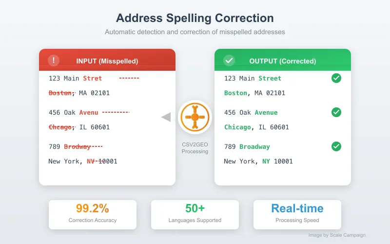
Automatic Spelling Correction
Real-world address data is messy. Typos happen. CSV2GEO's intelligent geocoding engine automatically corrects common misspellings, handling errors like "Calfornia" instead of "California" or "Main Stret" instead of "Main Street."
The system can even geocode addresses with missing components. If you only have a street address without the state name, CSV2GEO will still find the correct location based on city and zip code context.
Learn more about spell correction → Start Geocoding with Auto-Correction →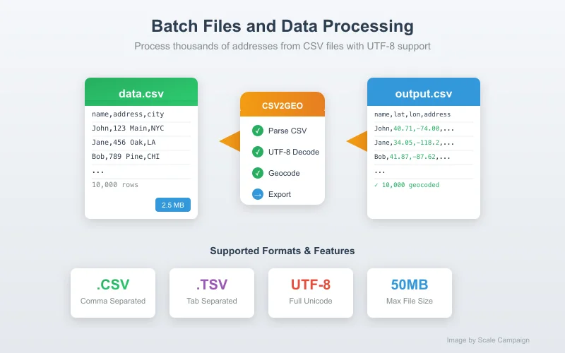
CSV and Excel File Support
Upload addresses in CSV (comma-separated values) or Excel format (.xlsx, .xls). CSV2GEO automatically detects your file's delimiter—whether commas, semicolons, tabs, or pipes—so you don't need to pre-process your data.
For best results with CSV files, use UTF-8 encoding to ensure special characters and international addresses are processed correctly. Excel files are converted automatically.
Learn more about file formats → Process Your CSV or Excel File →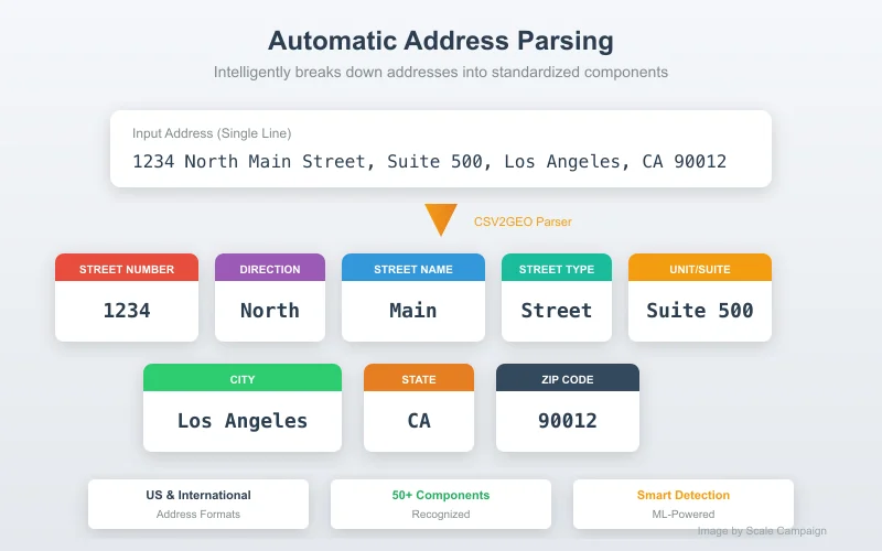
Intelligent Address Parsing
Whether your addresses are in a single column ("123 Main St, New York, NY 10001") or split across multiple columns (street, city, state, zip), CSV2GEO handles both formats automatically.
The parsing engine identifies address components even without proper punctuation, extracting street numbers, street names, unit numbers, cities, states, and postal codes from unstructured text.
Learn more about address parsing → Transform Your Addresses →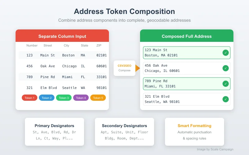
Structured Address Output
Beyond just coordinates, CSV2GEO returns standardized address components: street number, street name, city, state, postal code, and country in separate columns. This normalized output is perfect for data cleaning and standardization projects.
Secondary address elements like apartment numbers, suite designations, and building names are also parsed and included in the output when present in the original data.
Learn more about address components → Learn more about address normalization → Get Structured Address Data →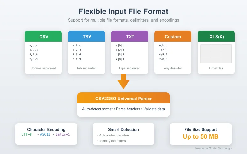
Non-Destructive Processing
CSV2GEO never modifies your original data. The geocoding results—latitude, longitude, accuracy score, and normalized address fields—are appended as new columns to the right of your existing data.
Your input file structure, column order, and all original values remain intact. This makes it easy to compare before and after, and ensures you never lose any source data during the geocoding process.
Learn more about output format → Upload Your File →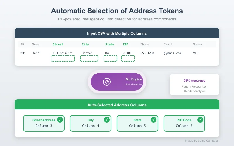
AI-Powered Column Detection
Don't waste time manually mapping columns. CSV2GEO's AI automatically detects which columns contain street addresses, cities, states, and postal codes based on column headers and data patterns.
Simply upload your file and let the system suggest the correct mappings. You can always adjust if needed, but most users find the auto-detection accurate enough to proceed immediately.
Learn more about auto-detection → Let AI Map Your Columns →Pricing That Scales With You
Start Free
Geocode 100 addresses free every day. No credit card required. See exactly how batch geocoding works before committing.
Pay As You Go
Need a one-time batch of 5,000 or 50,000 rows? Pay only for what you use. No subscription, no monthly commitment.
Monthly Plans
Geocoding regularly? Subscribe and save up to 80% per row. Process up to 500,000 rows/month with priority support.
API Access
Building an app or automating workflows? Our API handles millions of requests with real-time geocoding at scale.
Frequently Asked Questions
What is batch geocoding?
Batch geocoding (or bulk geocoding) is the process of converting multiple addresses into geographic coordinates (latitude and longitude) at once. Instead of geocoding addresses one by one, you can upload a CSV or Excel file with hundreds or thousands of addresses and get all coordinates back in a single operation. CSV2GEO is an online address geocoder that makes this process simple.
How many addresses can I geocode at once?
CSV2GEO can process files with up to 100,000 addresses in a single batch. Free users can geocode up to 100 addresses per day. For larger volumes, choose pay-as-you-go or monthly subscriptions for better per-row rates.
What file formats are supported?
CSV2GEO supports CSV (comma-separated values) and Excel (.xlsx, .xls) file formats. CSV files should be UTF-8 encoded for best results. Any delimiter (comma, semicolon, tab) is automatically detected.
How accurate is batch geocoding?
CSV2GEO uses multiple high-quality geocoding providers to ensure accuracy. Most addresses are geocoded to rooftop-level precision. The system also includes automatic spelling correction to handle minor typos in addresses.
Is my data secure?
Yes. All data is transmitted over HTTPS encryption. Your uploaded files are processed and then automatically deleted from our servers. We do not store, share, or sell your address data.
Can I geocode international addresses?
Yes, CSV2GEO supports geocoding addresses from most countries worldwide. The system automatically detects the country from the address or you can specify it in a separate column for better accuracy.
Is bulk geocoding the same as batch geocoding?
Yes, bulk geocoding and batch geocoding mean the same thing - processing many addresses at once rather than one at a time. Whether you call it bulk or batch, CSV2GEO handles both with the same powerful online geocoder. Upload your file and geocode thousands of addresses in minutes.
Can I convert addresses to lat long in bulk?
Yes. CSV2GEO is a bulk address to lat long converter. Upload a CSV or Excel file with your addresses and get latitude and longitude coordinates back for every row. You can process up to 100,000 addresses in a single batch, and the first 100 per day are free.
Ready to Geocode Your Addresses?
Join thousands of users who trust CSV2GEO for fast, accurate batch geocoding. Start with 100 free geocodes today.
Start Batch Geocoding Free