Feature 2 GIS – Georeferencing
Spatial Referencing for Images and Scanned Maps
Even from ancient times putting the curved surface of the Earth into plane surfaces like maps was a great challenge for cartographers. Consequently, cartographers had to find solutions in order to reduce the distortions created during the process of projecting the curved surface of the Earth into a plain surface. These solutions were represented by different mathematical operations and they were included into a new branch in cartography, namely map projections.
Map projections are used also in Geographical Information System (GIS) since the process of projecting the curved surface of the Earth into a plain surface is similar with the process did for paper maps. The difference is that in the GIS environment this process is done in digital format and usually the projections are already implemented in GIS software. Consequently, user should only use a few clicks to choose the desired projection for certain map(s).
However, there are situations when geospatial data may be obtained from scanned maps
or the user might need data from images or photos to be added into the GIS environment
in order to complete a project. In such situations, it is mandatory to add a map projection
to the data and this process is called georeferencing. Georeferencing can be defined as
that process when an image/photo is referenced using geospatial data that contain already spatial reference.
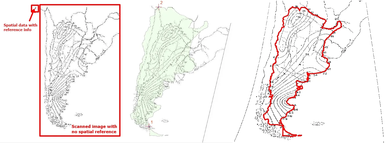
In the figures below you can notice the process of georeferencing:
(i) before georeferencing;
(ii) during georeferencing and
(iii) after georeferencing process is completed.
It can be noticed that the scanned map is much bigger than real world representation of country boundaries,
but after georeferencing boundaries match very accurate.
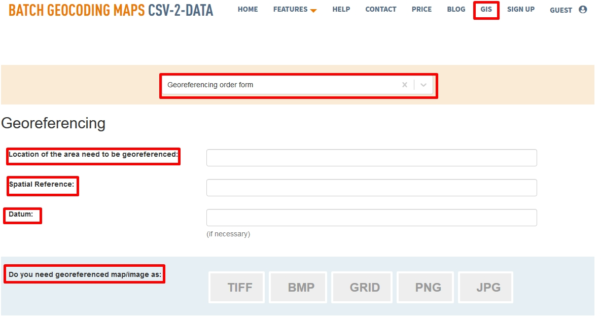
The georeferencing process can be time consuming and technical skills are needed in order to complete successfully such an operation in GIS. Consequently, at CSV2GEO you can find the help that you need in order to add a spatial reference to your data with such a spatial reference. At CSV2GEO the user will find implemented the order form called “Georeferencing” in the GIS menu. By completing this form with the necessary details, experts working at CSV2GEO will be able to add the necessary spatial reference to user’s data in order to use that data in the GIS environment in various projects.
However, it is highly important that the user complete all the fields available in the “Georeferencing” order form at CSV2GEO. During the georeferencing process each detail is useful in order to provide exactly the expected spatial reference. A spatial reference and a datum are mandatory in order to know exactly where the image that needs reference spatial should “fit” on the Earth surface. The term “spatial reference” is related to a map projection since in the world are numerous map projections and in certain GIS projects a specific map projection is required, while the term “datum” refers to a local position of the surface relative to the center of the Earth. Moreover, the user should choose which type of format should be the georeferenced image by choosing from TIFF, BMP, GRID, PNG or JPG. Usually, in most situations the file format is TIFF.
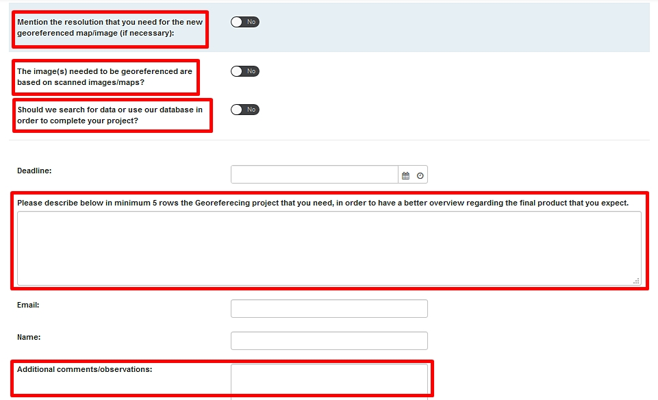
As soon as the user has completed the above mentioned fields, the user has other several fields to complete, fields that might be useful for GIS experts at CSV2GEO during the georeferencing process. During the georeferencing process it is possible to change the resolution of the georeferenced image/photo and consequently if the user requires a certain resolution, this aspect should be mentioned there. Another aspect that should be pointed out is if the image necessary to be georeferenced is scanned. However, this aspect is important because the quality of the scan can influence the georeferencing process. Moreover, if the user doesn’t hold the data needed for the project or part of the data, the user can require to our experts to try finding the necessary data. Furthermore, before sending the “Georeferencing” order form the user should complete with more details or additional comments to this order form. By doing so, it is more prone for the user to get the expected product.
The great advantage of using this order form at CSV2GEO is that you can obtain the necessary data georeferenced with a high accuracy. Moreover, since very often the georeferencing process requires technical skills and experience, it can be time consuming. By applying to the form available at CSV2GEO, you will get the data into a very short time, saving precious time for your project and for your business. Additional forms such as Data Conversion and Management, Geovisualization , GPS Data and few others are provided as services.