How to Convert Address to Latitude and Longitude
Convert address to lat long for free — single lookup, bulk CSV/Excel upload, or API. Get latitude and longitude from any address with rooftop accuracy across 200+ countries.
Converting an address to latitude and longitude — called forward geocoding — is the process of taking a human-readable location like "1600 Pennsylvania Ave NW, Washington, DC" and returning the two numbers that pinpoint it on Earth: 38.8977, -77.0365. Every mapping application, GPS device, and location-based service in the world runs on these coordinates.
This guide covers three methods for converting addresses to lat/long — from a single free lookup to bulk file processing to programmatic API access. It also explains what coordinates actually mean, how precision affects your results, and what determines whether you get rooftop accuracy or just a city-center approximation.
What Are Latitude and Longitude?
Latitude and longitude are the two numbers in the geographic coordinate system that define any point on Earth. Latitude measures north-south position: 0 at the equator, +90 at the North Pole, -90 at the South Pole. Longitude measures east-west position: 0 at the Prime Meridian (Greenwich, London), +180 going east, -180 going west.
Together, they form a unique address for every square meter on the planet. When you convert an address to lat long, you are translating from one addressing system (street names, postal codes, human conventions) to another (mathematical coordinates). Both point to the same physical location — coordinates are just the machine-readable version.
| Location | Address | Latitude | Longitude |
|---|---|---|---|
| White House | 1600 Pennsylvania Ave NW, Washington, DC | 38.8977 | -77.0365 |
| Big Ben | Westminster, London SW1A 0AA, UK | 51.5007 | -0.1246 |
| Tokyo Tower | 4-2-8 Shibakoen, Minato-ku, Tokyo | 35.6586 | 139.7454 |
| Christ the Redeemer | Parque Nacional da Tijuca, Rio de Janeiro | -22.9519 | -43.2105 |
| Sydney Opera House | Bennelong Point, Sydney NSW 2000 | -33.8568 | 151.2153 |
Notice the signs: Washington and London have positive latitudes (northern hemisphere) while Rio and Sydney have negative latitudes (southern hemisphere). London has a slightly negative longitude (just west of the Prime Meridian) while Tokyo is far east at 139 degrees.
How Coordinate Precision Affects Accuracy
Not all coordinate lookups are equally precise. The number of decimal places in your lat/long determines how accurately the point is placed on the ground. More decimals do not always mean better — they mean more specific.
| Decimal Places | Precision | Distance | Use Case |
|---|---|---|---|
| 0 (40, -74) | ~111 km | Country/region level | Weather maps, continental analysis |
| 1 (40.7, -74.0) | ~11.1 km | Large city area | City-level mapping |
| 2 (40.74, -74.00) | ~1.1 km | Neighborhood | District-level analysis |
| 3 (40.748, -73.986) | ~111 m | Street block | Street-level geocoding |
| 4 (40.7484, -73.9857) | ~11 m | Building | Rooftop geocoding (standard) |
| 5 (40.74844, -73.98566) | ~1.1 m | Individual entrance | Surveying, precision logistics |
CSV2GEO returns coordinates with 4-6 decimal places, which is rooftop-level precision — accurate enough to identify a specific building. For most use cases (mapping, routing, analysis), 4 decimal places is the practical sweet spot.
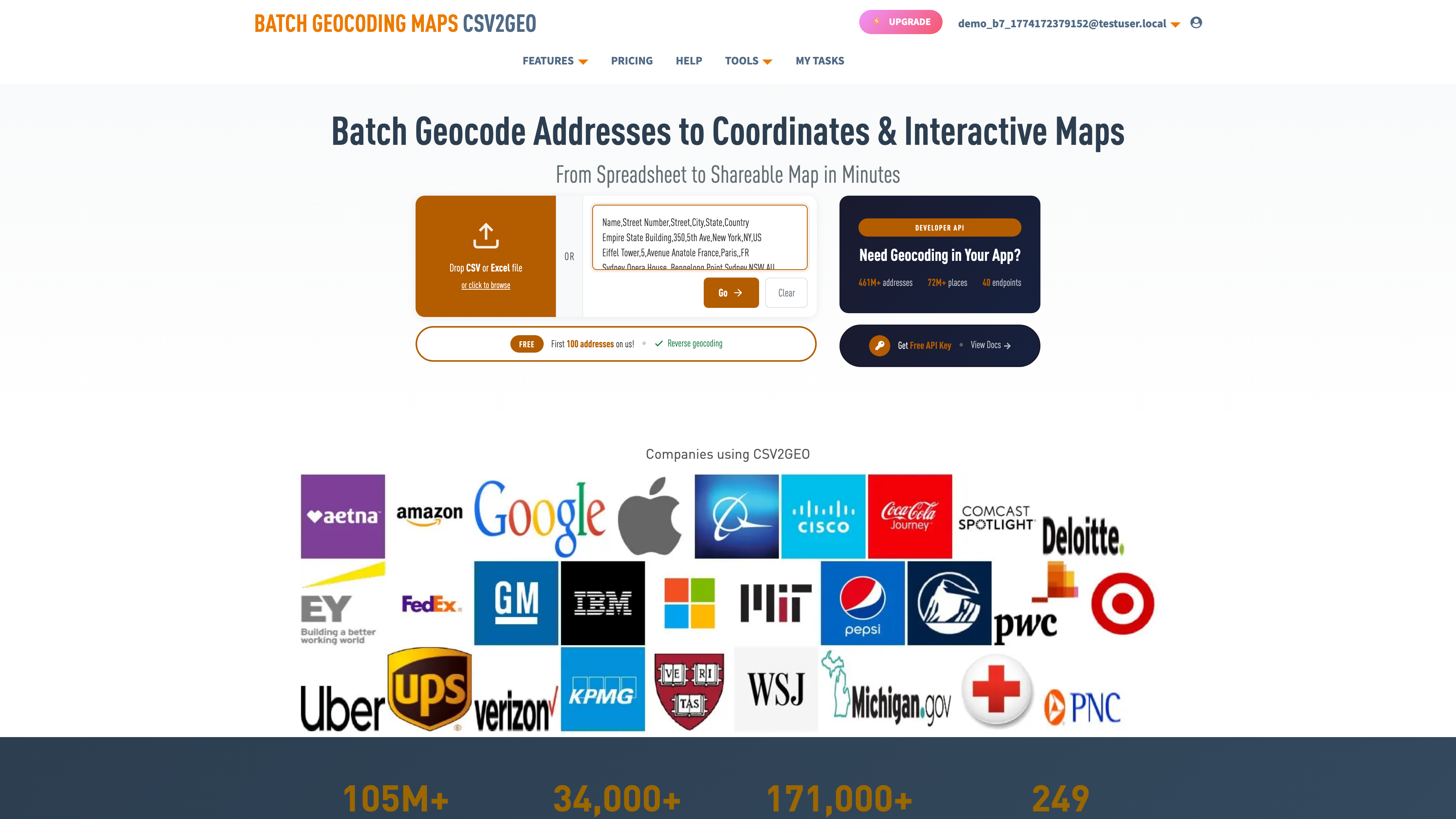
Method 1: Single Address Lookup (Free, Instant)
The fastest way to convert one address to lat/long is a direct lookup. Go to csv2geo.com/batchgeocoding, type your address into the text area, and click "Go." The system returns latitude, longitude, and a relevance score within seconds.
Example:
| Input Address | Latitude | Longitude | Relevance |
|---|---|---|---|
| 1600 Pennsylvania Ave NW, Washington, DC | 38.8977 | -77.0365 | 1.0 |
| 10 Downing Street, London, UK | 51.5034 | -0.1276 | 1.0 |
| Champs-Élysées 101, Paris, France | 48.8738 | 2.2950 | 1.0 |
A relevance score of 1.0 means rooftop accuracy — the coordinates point directly to the building. No account needed for single lookups. You can also try this in ChatGPT using the CSV2GEO Geocoder GPT — type any address and get coordinates back instantly.
Method 2: Bulk Convert Address to Lat Long (CSV or Excel)
When you have dozens, hundreds, or thousands of addresses, uploading a file is dramatically faster than looking them up individually. At 30 seconds per manual lookup, a 1,000-row spreadsheet would take over 8 hours. Batch geocoding does it in two minutes.
How it works:
- Upload your CSV or Excel file to csv2geo.com/batchgeocoding — drag and drop, or click Browse.
- The system displays your data and auto-detects address columns using an AI module. Green labels show which column is street, city, state, zip, country.
- Review the column mappings. Adjust anything the AI got wrong by clicking the column header.
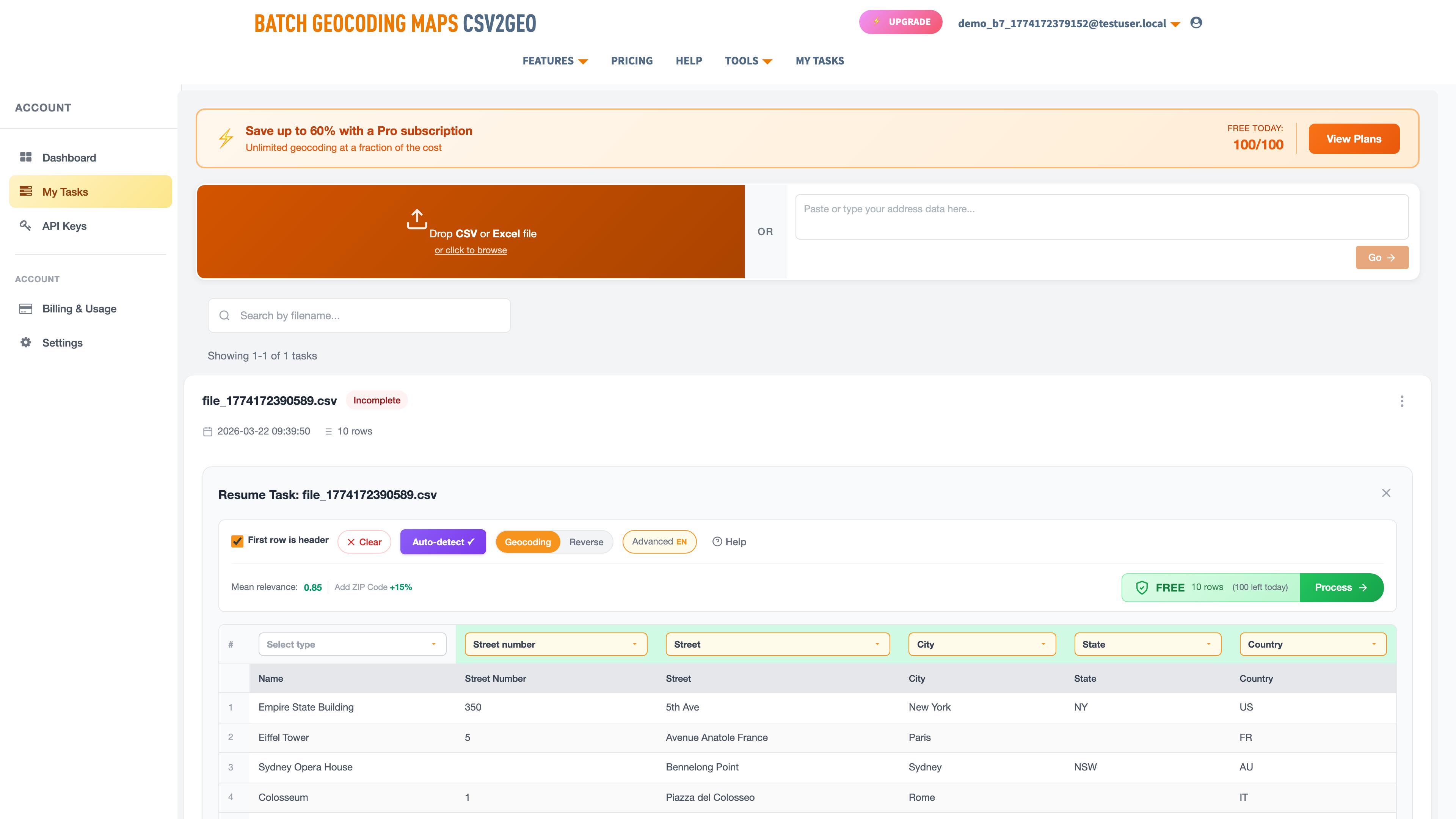
- Click "Process Data" to preview the first 10 geocoded rows. Check that coordinates and relevance scores look correct.
- Click "Get All Data" to process the entire file. Download the result with lat/long appended to every row.
The free tier processes 100 addresses per day — no credit card required. For detailed file upload walkthroughs, see the CSV geocoding guide or the Excel geocoding guide.
Get Lat Long from Address in Excel
If your addresses live in an Excel spreadsheet, you do not need a plugin or a macro to convert them to coordinates. The most reliable approach is to save your spreadsheet as a CSV, upload it to CSV2GEO, and download the result with latitude and longitude columns appended. Here is the step-by-step process:
Save as CSV. In Excel, go to File → Save As and choose "CSV (Comma delimited)." This strips formatting and formulas, leaving clean text data that any geocoding tool can read. If your spreadsheet has multiple sheets, save the one with addresses — CSV only supports a single sheet.
Check your columns. Make sure your address data has clear column headers. Ideally, separate columns for street, city, state, zip, and country. A single "Full Address" column works too — CSV2GEO parses both formats — but separate columns produce 10-15% higher match rates because the parser does not need to guess where the city ends and the state begins.
Upload to CSV2GEO. Go to csv2geo.com/batchgeocoding and drag your CSV file onto the upload area. The system previews your data and highlights which columns it detected as address components. Confirm the mapping and click Process Data.
Download the result. Your original file comes back with new columns: latitude, longitude, full resolved address, and a relevance score. Open the downloaded CSV in Excel — all your original data is intact, with coordinates added as new columns on the right.
This workflow handles files with thousands of rows and does not require any Excel add-ins, VBA scripts, or API keys. The free tier covers 100 addresses per day. For a detailed walkthrough with screenshots, see the Excel geocoding guide.
Method 3: Geocoding API for Developers (1,000 Free/Day)
If you need to convert addresses to coordinates inside an application, a data pipeline, or a script, the CSV2GEO geocoding API provides 18 endpoints for forward geocoding, reverse geocoding, batch processing, places search, and boundary lookups.
curl "https://csv2geo.com/api/v1/geocode?q=1600+Pennsylvania+Ave+NW,+Washington+DC&country=US&api_key=YOUR_KEY"Python SDK:
from csv2geo import Client

client = Client("YOUR_API_KEY")
result = client.geocode("1600 Pennsylvania Ave NW, Washington DC", country="US")
print(f"Lat: {result.lat}, Long: {result.lng}")
# → Lat: 38.8977, Long: -77.0365
JavaScript (Node.js):
const response = await fetch(
  "https://csv2geo.com/api/v1/geocode?q=10+Downing+Street,+London&country=GB&api_key=YOUR_KEY"
);
const data = await response.json();
console.log(data.lat, data.lng);
// → 51.5034 -0.1276
Install the Python SDK with pip install csv2geo. Get your free API key at csv2geo.com/api-keys. The batch endpoint processes up to 10,000 addresses per request.
How Address-to-Coordinate Conversion Works
When you submit an address for geocoding, the system does not simply look up a string in a database. It runs through a multi-step process designed to handle the enormous variation in how people write addresses around the world.
- Address parsing — the input string is broken into components: house number, street, city, state, postal code, country. An address parser (often powered by machine learning) handles abbreviations ("St" → "Street"), word order differences (house number before vs after street name), and missing components.
- Normalization — parsed components are standardized. "NYC" becomes "New York City." "CA" becomes "California." Accented characters are preserved but alternative spellings are mapped (München = Munich, 東京 = Tokyo).
- Country routing — the system determines which country-specific database to search. This is why including a country code is so important — it narrows the search from 200+ countries to one.
- Address matching — the normalized components are matched against a database of known addresses. CSV2GEO searches through 461 million rooftop-level records. The system tries exact matches first, then progressively relaxes criteria (dropping house number, then street, falling back to postal code or city centroid).
- Scoring — each result gets a relevance score from 0 to 1.0 reflecting how closely the input matched the database record. A perfect house-number match scores 1.0. A postal-code fallback scores 0.3-0.5.
- Coordinate return — the matched address record includes pre-computed coordinates (latitude, longitude) stored in the WGS84 reference system, along with the full parsed and standardized address.
This entire process happens in milliseconds per address. When batch processing a CSV file, CSV2GEO parallelizes the lookups across multiple workers, which is why 1,000 addresses complete in about two minutes.
Tips for Getting Rooftop-Level Accuracy
The difference between a 1.0 relevance score and a 0.5 often comes down to input quality. Here are the factors that matter most.
Include the house number. "350 5th Ave, New York" returns the exact building (Empire State Building, 40.7484). "5th Ave, New York" returns a point somewhere along a 4-mile-long avenue. The house number is the single most important field for rooftop accuracy.
Always specify the country. "Paris" matches Paris, France (48.8566, 2.3522) but also Paris, Texas (33.6609, -95.5555). "Springfield" exists in 34 US states. An explicit country code eliminates this ambiguity.
Use structured input when possible. Separate columns for street, city, state, and zip produce 10-15% higher match rates than a single combined address field. The parser is good at splitting combined addresses, but separate columns remove guesswork.
Provide postal codes when you have them. A correct postal code narrows the search area from an entire country to a few square kilometers. Even if the street name has a typo, a good postal code often recovers the correct match.
Remove non-address noise. "c/o John Smith, Apt 4B, Ring buzzer #7, 350 5th Ave, New York" — the delivery instructions confuse the parser. Move suite numbers, contact names, and delivery notes to separate fields.
What Determines the Accuracy of Your Coordinates?
When you convert an address to lat long, the result can range from rooftop-level precision (coordinates on the building) to city-center approximation (coordinates in the middle of the city). Several factors control which one you get.
Address Specificity
A complete address with house number, street, city, zip, and country gives rooftop precision. A partial address ("New York, US") returns the city centroid — 40.7128, -74.0060 — which is Times Square, not your actual location.
Database Coverage
CSV2GEO has 461M+ rooftop addresses across 200+ countries, with the deepest coverage in the US (121M), Brazil (90M), Mexico (30M), France (26M), and Italy (26M). Rural areas in developing countries have sparser coverage.
Relevance Score
Every result includes a score from 0 to 1.0. A score of 1.0 means exact rooftop match. Between 0.8–1.0 is very reliable. Below 0.5 means the geocoder fell back to city or postal code level.
Address Quality
Typos, abbreviations, missing components, and outdated addresses reduce accuracy. "123 Main St, NYC" works; "123 Main, NY" is ambiguous. The more complete your input, the better your output.
Coordinate Formats: Decimal Degrees vs DMS
Coordinates come in two main formats. When you convert address to lat long, make sure you are using the right one for your application.
| Format | Example (White House) | Used By |
|---|---|---|
| Decimal Degrees (DD) | 38.8977, -77.0365 | Google Maps, QGIS, Tableau, APIs, databases, GPS — the standard for all modern software |
| Degrees Minutes Seconds (DMS) | 38° 53' 51.7" N, 77° 2' 11.4" W | Aviation, marine navigation, traditional cartography, military |
CSV2GEO outputs decimal degrees exclusively — this is the format that 99% of modern tools expect. If you need DMS for aviation or marine use, convert using the formula: degrees + (minutes/60) + (seconds/3600).
Converting International Addresses
Address formats vary dramatically by country. A US address has a street number before the street name; a Japanese address starts with the prefecture and works inward to the building number. A German address puts the house number after the street. CSV2GEO handles all of these conventions.
| Country | Address Format Example | Result |
|---|---|---|
| 🇺🇸 United States | 350 5th Ave, New York, NY 10118 | 40.7484, -73.9857 |
| 🇬🇧 United Kingdom | 221B Baker Street, London NW1 6XE | 51.5238, -0.1585 |
| 🇩🇪 Germany | Brandenburger Tor, Pariser Platz, 10117 Berlin | 52.5163, 13.3777 |
| 🇧🇷 Brazil | Av. Atlântica 1702, Copacabana, Rio de Janeiro | -22.9668, -43.1789 |
| 🇦🇺 Australia | Bennelong Point, Sydney NSW 2000 | -33.8568, 151.2153 |
| 🇮🇹 Italy | Piazza del Colosseo 1, 00184 Roma | 41.8902, 12.4922 |
Key tip: Always include the country code (US, GB, DE, BR, AU, IT) or full country name. Without it, the geocoder cannot distinguish between "Paris, France" and "Paris, Texas" — or the dozens of Springfields across the US and beyond.
Why Convert Addresses to Coordinates?
Every tool in the location intelligence stack — from simple map pins to complex spatial analysis — runs on coordinates, not street addresses. Converting your address data to latitude and longitude is the step that makes everything else possible.
Map visualization. Google Maps, Leaflet, Mapbox, QGIS, Tableau, and every other mapping library requires numeric coordinates to place a marker. Street addresses are meaningless to a map renderer. Whether you are plotting customer locations, store territories, or delivery stops, the first step is always address to lat long.
Distance and routing. Computing the distance between two locations, or building an optimal route through a sequence of stops, requires coordinates for every point. Delivery teams, field service crews, and sales reps all depend on geocoded addresses to plan efficient routes and minimize drive time.
Territory planning and CRM enrichment. Sales organizations assign reps to geographic territories, score leads by proximity to existing customers, and segment markets by region. All of this requires address data converted to coordinates so it can be plotted, measured, and divided on a map.
Risk assessment and compliance. Insurance companies overlay property coordinates with flood zones, wildfire risk maps, and seismic hazard layers. Real estate professionals cross-reference listings with school districts and comparable sales. Government agencies verify that facilities comply with geographic zoning requirements. None of this works without geocoded addresses.
Research and spatial analysis. Epidemiological studies, crime pattern analysis, environmental monitoring, and demographic research all start by geocoding address records. Once addresses become coordinates, researchers can apply clustering algorithms, heat maps, and statistical models to reveal geographic patterns invisible in raw address lists.
- Map visualization — every mapping tool (Google Maps, Leaflet, Mapbox, QGIS, Tableau) requires lat/long, not street addresses
- Distance calculation — computing the distance between two addresses requires coordinates for both (using the Haversine formula or a routing API)
- Route optimization — delivery, field service, and sales teams need coordinates to build optimal routes through GPS routing engines
- CRM enrichment — append geographic intelligence to customer records for territory planning, lead scoring, and market analysis
- Geofencing — define geographic boundaries (store radius, delivery zones, service areas) using coordinate polygons
- Spatial analysis — epidemiological studies, crime mapping, environmental monitoring, and demographic research all start with geocoded addresses
Frequently Asked Questions
How do I convert an address to latitude and longitude?
Go to csv2geo.com/batchgeocoding, type your address, and click Go. You get latitude, longitude, and a confidence score instantly. For multiple addresses, upload a CSV or Excel file. For programmatic access, use the API.
Can I convert multiple addresses to lat long at once?
Yes. Upload a CSV or Excel file with your addresses. CSV2GEO batch converts all rows and returns a file with lat/long columns appended. 100 rows per day free, no credit card. See our CSV geocoding guide for a walkthrough.
What coordinate format does CSV2GEO use?
Decimal degrees using the WGS84 standard — the same format used by Google Maps, GPS devices, and all modern mapping software. Example: 40.7484, -73.9857.
How accurate is address-to-coordinate conversion?
CSV2GEO provides rooftop-level accuracy for 461 million addresses across 200+ countries. Every result includes a relevance score from 0 to 1.0 — a score of 1.0 means the coordinates point to the exact building.
How many addresses can I convert for free?
100 addresses per day via file upload, 1,000 per day via API. Both reset every 24 hours. No credit card required.
What countries are supported?
200+ countries. The deepest coverage is in the US (121M addresses), Brazil (90M), Mexico (30M), France (26M), and Italy (26M). Addresses in all other countries are matched using fallback geocoding strategies.
Can I go the other way — coordinates to address?
Yes, that is called reverse geocoding. Upload a file with latitude and longitude columns, or use the reverse geocoding tool. See our reverse geocoding guide for details.
Do I need to install any software?
No. Everything runs in your browser — no downloads, no plugins. Upload your file, get coordinates, download the result. Works on Chrome, Firefox, Safari, and Edge.
Convert Your Addresses to Coordinates Now
Ready to convert address to lat long? Try a single lookup for free, or upload a CSV/Excel file to batch convert hundreds of addresses at once. 100 rows free every day, no credit card.
For developers, the geocoding API provides 18 endpoints with 1,000 free requests per day. For the reverse direction, use our reverse geocoding tool.
Need help? Visit our Help center or contact us.
I.A.
CSV2GEO Creator
Related Articles
Use our batch geocoding tool to convert thousands of addresses to coordinates in minutes. Start with 100 free addresses.
Try Batch Geocoding Free →