How to Map Your Data with Interactive Maps on CSV2GEO
The world can be easier understood using maps as geographic tools to visualize and analyze different features. Nevertheless, in the past decades mapping experienced a progress due to the digital technology and Geographic Information System (GIS). Moreover, GIS is the domain that nowadays has a remarkable progress and development. Consequently, based on the development of Geographic Information System most of the maps done on paper in the past are nowadays available in digital format. Accordingly, digital maps are available both as static digital maps or interactive digital maps. The advantages of digital maps are manifold and a large number of domains are using nowadays digital maps in a wide range of applications. However, we are sure that you have used or at least you know applications such as Uber, Booking.com, AirBnb or Strava. These applications use in their background digital maps and digital data that have been previously geocoded in order to show zip postal code addresses on the map.
Converting zip postal codes into geographic coordinates and vice-versa
If you are searching for a place into a human community, you may need a place address or a zip postal code, while if you are travelling into the natural environment for different purposes, for sure you will need a geographic location defined by latitude and longitude. Consequently, you may need to use geocoding or reverse geocoding to obtain the exact location of your destination. Geocoding represents that operation that transforms addresses as zip codes into geographic coordinates as latitude and longitude. On the other hand, the opposite operation, namely reverse geocoding, transforms the numerical geographical coordinates into postal addresses.
At CSV2GEO, you can easily convert your data sets from geographic locations into postal code addresses or vice-versa - from postal addresses into numerical coordinates on the Earth surface. Consequently, by using just few clicks you can run very easy geocoding or reverse geocoding process. You can discover how you can convert an address into latitude and longitude or vice-versa in one previous article available on our website related to endangered species. Moreover, you can convert large data sets since batch geocoding processes are available if you want to obtain geographic coordinates for more locations at once.
Discover ‘Interactive Maps' feature at CSV2GEO
A new feature is now available on CSV2GEO website, namely ‘Create Interactive Maps' tool. This tool allows you to map your geocoded or reverse geocoded data on an interactive map.
Let's discover how you can use the feature ‘Create Interactive Maps' on CSV2GEO website. First of all, you should log in into the website going to your username and password. After this step, you can upload your data sets as files with csv extension. Then you must proceed with the geocoding or reverse geocoding processes, basing on what kind of data you have. Going further, you will have occasion to download your data. On the same page, you will notice a button named "Map It".
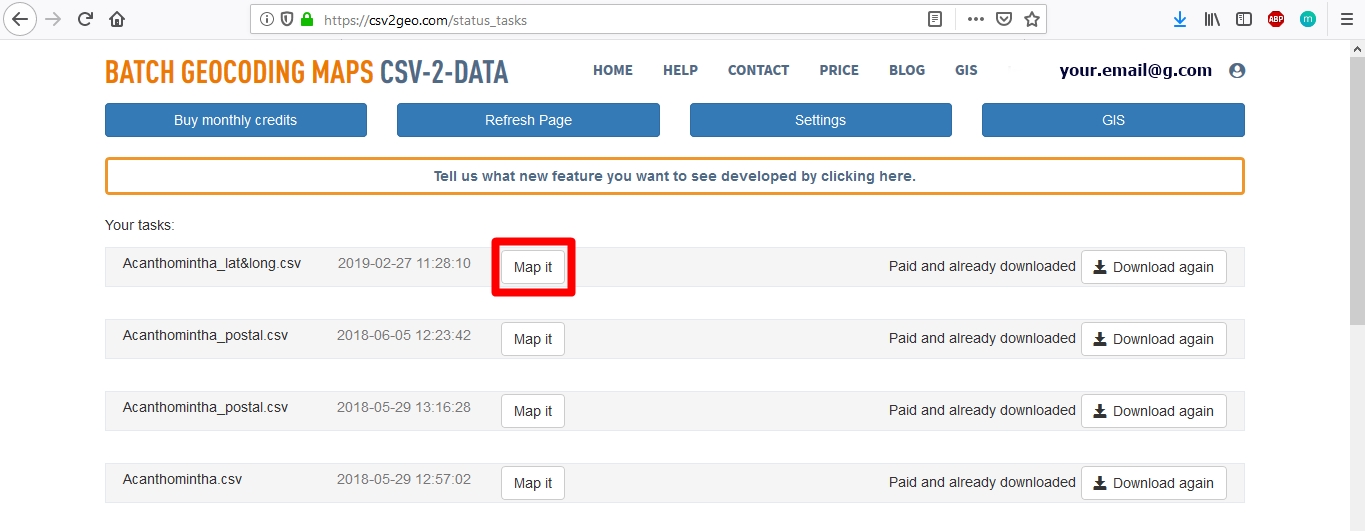
That button will plot your data on an interactive map. If you have diverse data sets in your work history on CSV2GEO website, you may also create interactive maps using that data. These are the steps that you should follow to have your data on an interactive map with geocoded data on the CSV2GEO website.
Advantages of ‘Create Interactive Maps' tool
There are plenty benefits of using ‘Create Interactive Maps' feature available at CSV2GEO website. First of all, you can verify your data immediately after you run the geocoding or reverse geocoding processes. Secondly, you may make the map that you need without importing your data sets into other software. On the same platform where you have geocoded or reverse geocoded your data sets, you may display those data sets into an interactive map. Consequently, you will not need any additional mapping software to build your maps.
Another advantage of this feature available at CSV2GEO website is that you may choose different types of base maps and you can set the scale for your map. You may also take advantage of the possibility to group your data based on different attributes available in the table of attributes.
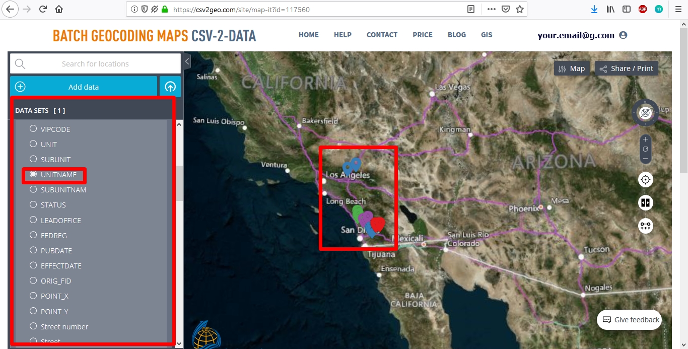
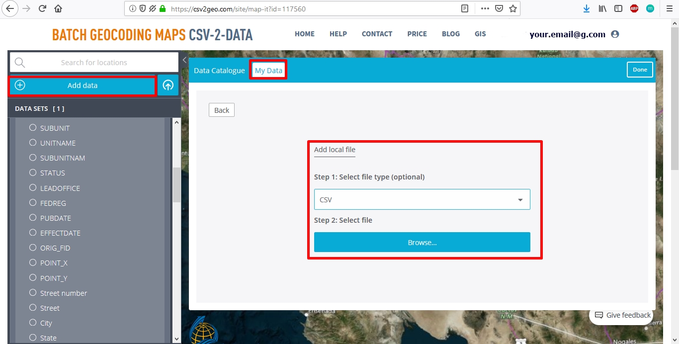
Moreover, adding other data from external sources as your own computer represents another great advantage since you are able to put together your geocoded or reverse geocoded data with different types of data sets. Accordingly, you can integrate data as KML, GPX, GeoJSON or CSV. Additionally, you can add also data available on the Internet from sources as for example the ESRI servers or the Open Street Maps servers However, by having access to these interactive maps, you can develop different kinds of spatial analyses directly on the same platform that you used before to convert geographical coordinates into zip postal codes or vice-versa.
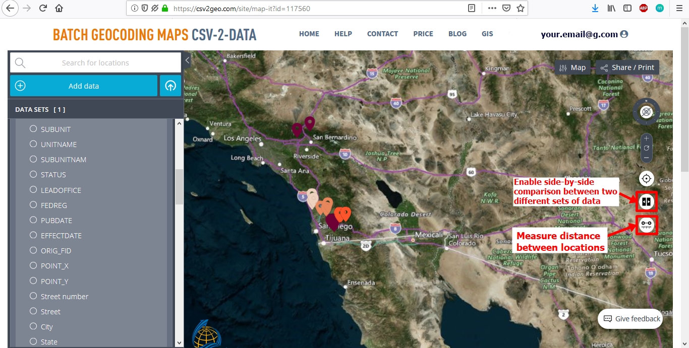
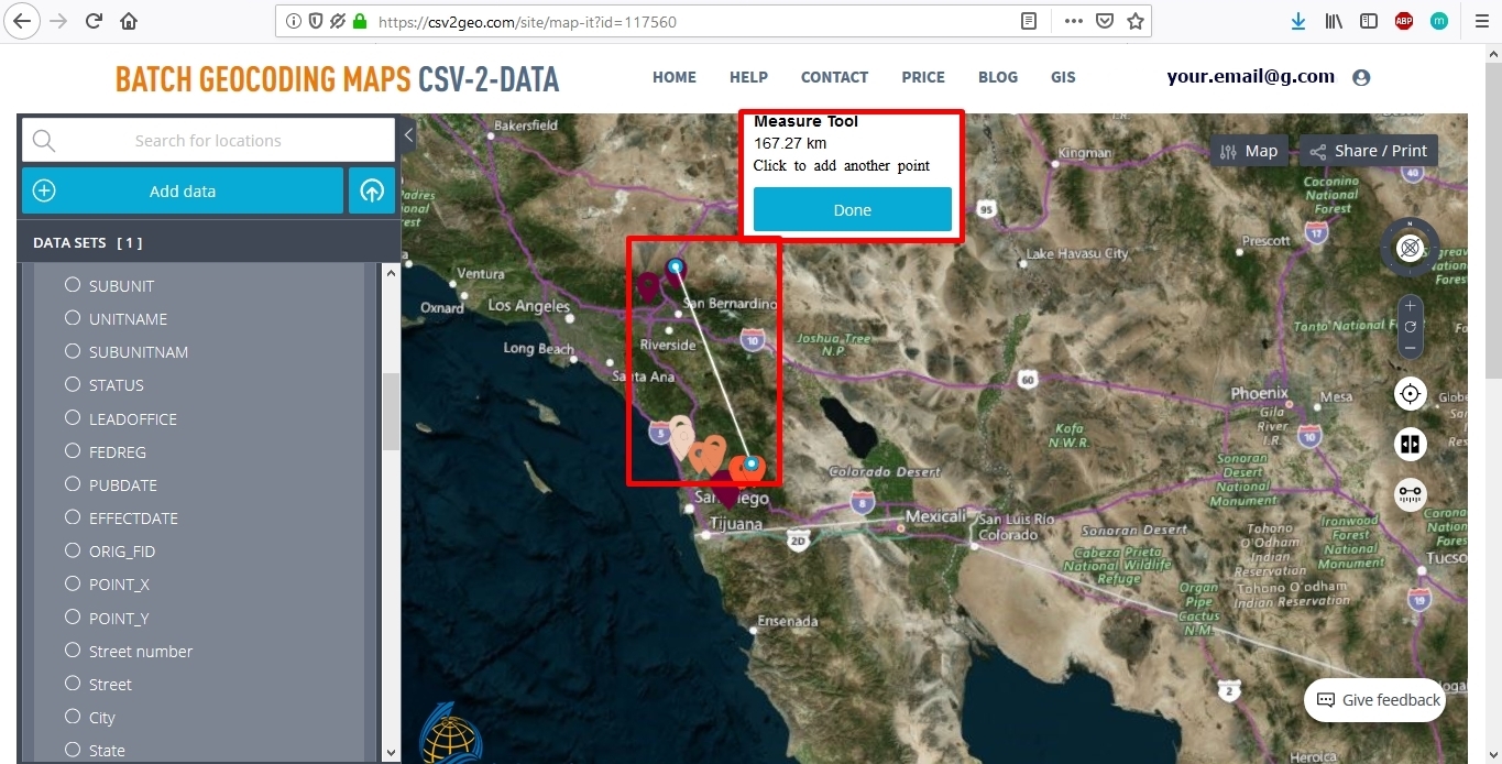
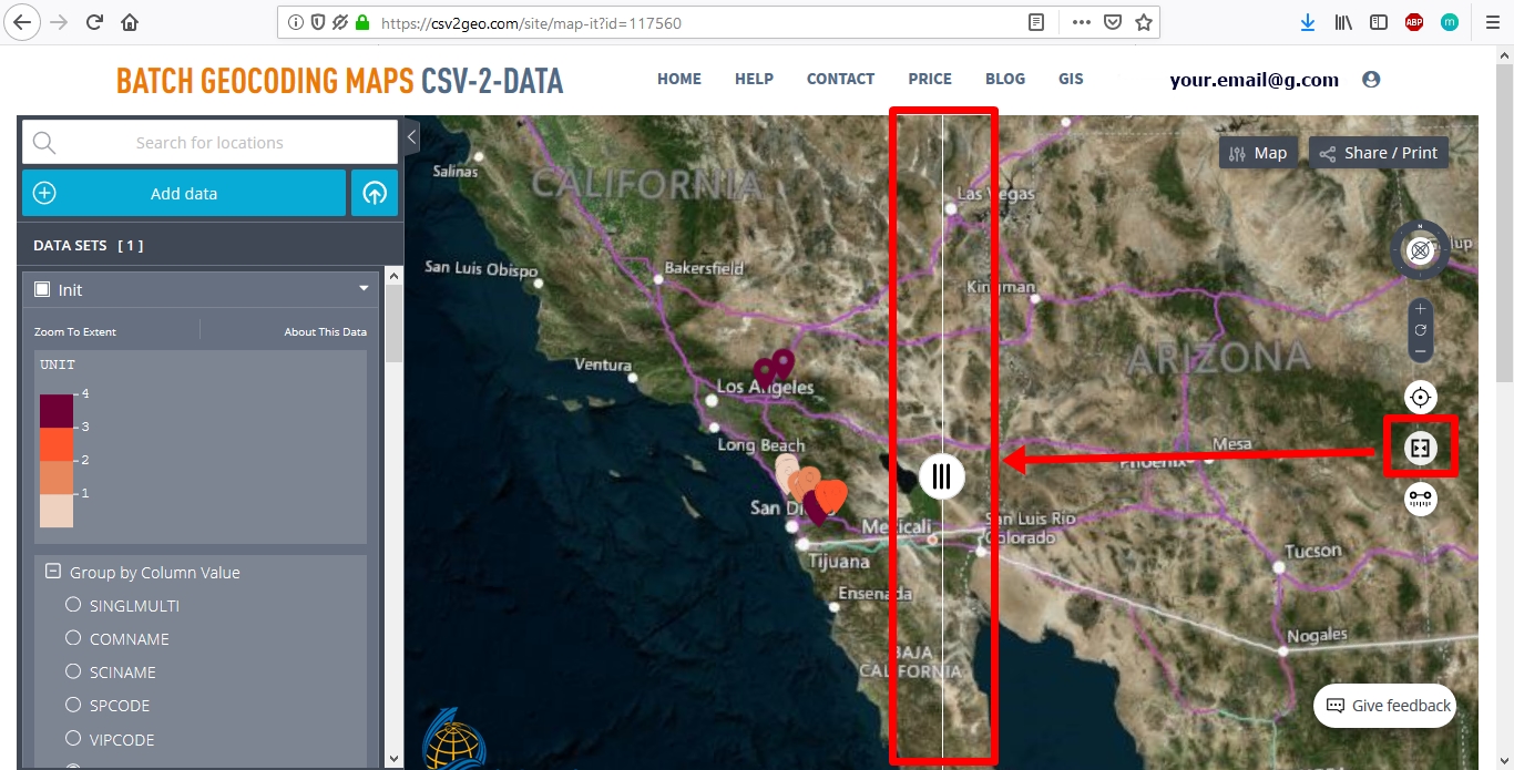
Furthermore, this feature has some significant functionality. Maybe you want to know the distance between different points on your map. In this case, you can utilize the tool "Measure distance between locations". Another fantastic tool is "Enable side-by-side comparison between two different sets of data". This tool allows you to see in the same window a comparison of two distinct data sets at the same time and it may be helpful if you need to develop a comparison study regarding a phenomenon or to show a spatial distribution change.
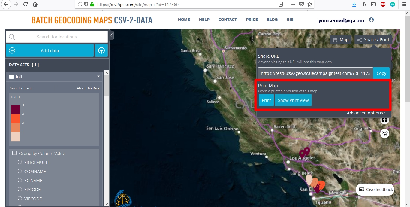
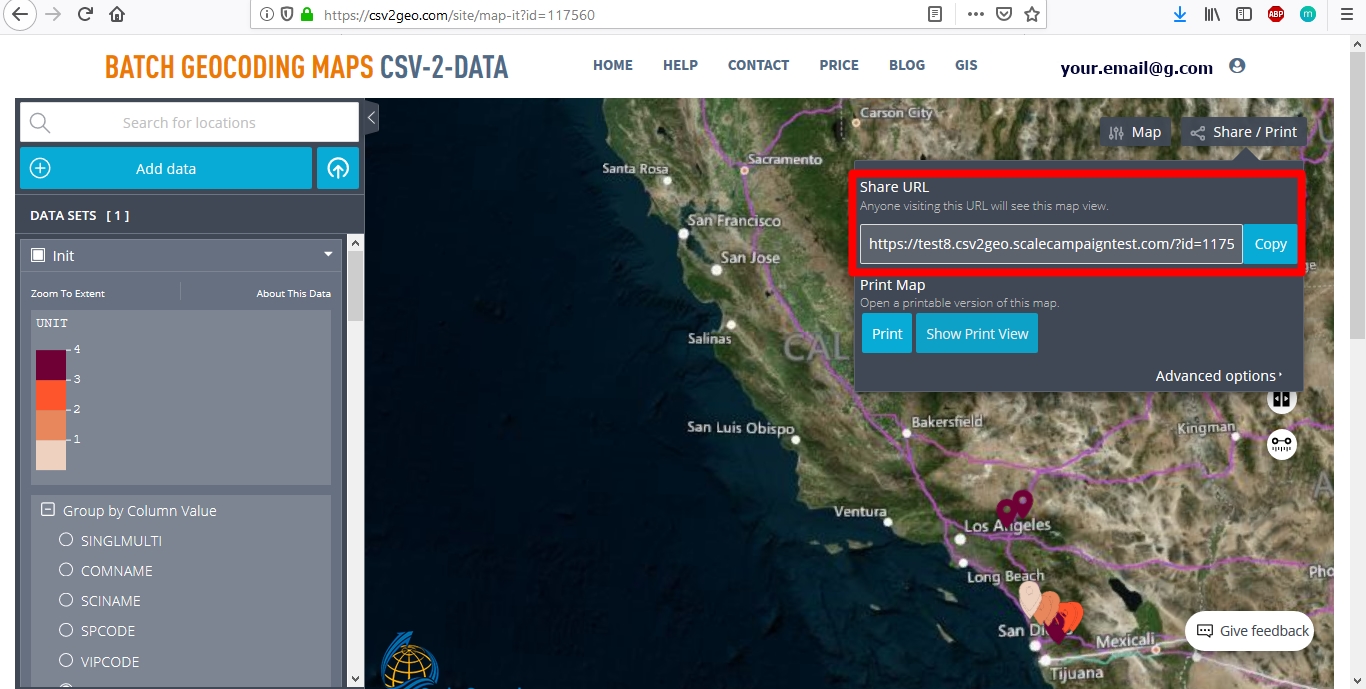
As soon as your map it is ready and you are satisfied with it, you can print your map or you can share it using the link available on CSV2GEO website.
The bottom line
Currently, digital mapping and location intelligence have a common point in using GIS for different purpose. Accordingly, many applications are using these kinds of technologies in various domains as for example business, tourism, travel, natural disasters' management and environmental protection. In any field would you need to use geocoding and reverse geocoding processes, at CSV2GEO you will have now the opportunity to create your own maps using the data sets that you have converted. By integrating this feature of interactive maps, CSV2GEO has proposed enhancing the interoperability between data sets and spatial representations utilizing maps and digital maps. Since ScaleCampaign provides access to batch geocoding services, you have the capability to display on interactive maps the geographical coordinates for more locations simultaneously. Interactive maps available at CSV2GEO are user-friendly, easy to edit, customizable, printable and ready to share them with your friends, clients or colleagues.
Use our batch geocoding tool to convert thousands of addresses to coordinates in minutes. Start with 100 free addresses.
Try Batch Geocoding Free →